The Stalker’s Art: What Is SOCMINT, How Digital Vanity Kills Armies, and Why Nothing Is Ever Private
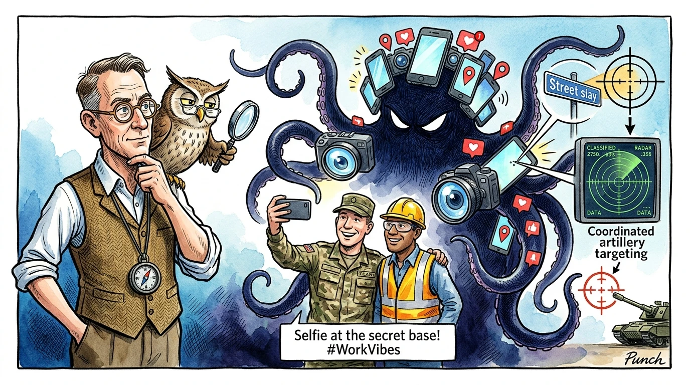
Social Media Intelligence (SOCMINT) has inverted modern warfare. Where 20th-century states spent billions on spy satellite constellations, modern military units and critical infrastructure operators are routinely compromised by the unforced digital vanity of their own personnel broadcasting geotagged breadcrumbs to the world.
SOCMINT stands for Social Media Intelligence. It is the systematic tradecraft of harvesting, verifying, and analyzing publicly available information across social platforms—including Telegram, TikTok, X (formerly Twitter), Instagram, Strava, Reddit, VKontakte, and YouTube—to extract actionable military, geopolitical, and humanitarian intelligence.
1. The Paradigm Shift in Modern Surveillance
To understand the scale of this paradigm shift, compare traditional espionage with open-source collection:
- Traditional Espionage: A trained intelligence operative sneaks into a heavily guarded sovereign facility at midnight, photographs physical documents in a safe, and extracts microfilm at extreme personal risk.
- SOCMINT: Analysts sit in an office thousands of miles away, passively monitoring the digital breadcrumbs that soldiers, government contractors, and utility workers voluntarily broadcast to the global public every second.
Every day, billions of internet users upload selfies, gym workouts, dashcam videos, and workplace updates. To the untrained eye, these posts appear utterly mundane. To a trained SOCMINT investigator, however, a single 10-second TikTok can reveal the exact GPS coordinates of a concealed command bunker, expose corrupt shell company networks, compromise critical communication infrastructure, or deliver empirical ground truth for humanitarian crisis relief.
2. Core Categories: The Four Streams of SOCMINT Tradecraft
Professional SOCMINT analysis is rigorous digital forensic science. Investigators break down social data across four distinct analytical streams:
Visual Geolocation (The "Where")
Visual geolocation is the art of ignoring the subject of a photograph and forensically interrogating the background. Analysts scan for unique geographic and architectural markers: natural topography (distinctive mountain ridge angles, river bends, tree species), man-made infrastructure (high-voltage transmission tower designs, socket types, road paint, railway track gauges, building roof profiles), and textual artifacts (billboard phone numbers, municipal street address signs, business logos).
Chronolocation (The "When")
Chronolocation determines the exact day, hour, and minute an image or video was recorded. Investigators utilize astronomical and meteorological modeling: calculating solar shadow azimuth angles and shadow lengths relative to the sun (via tools like SunCalc), cross-referencing cloud formations with historical satellite Doppler weather feeds, and correlating commercial storefront opening hours.
Telemetry & App Exhaust (The "Digital Footprint")
Modern connected applications continuously leave a trail of digital exhaust: fitness tracker heatmaps (Garmin, Strava, Apple Watch) logging speed, elevation, and GPS trails; Exchangeable Image File (EXIF) metadata revealing camera sensor hashes and unstripped coordinates; and public geotags or check-ins on social platforms.
Social Network & Graph Mapping (The "Who and Why")
Adversaries map relationships between personnel by scraping public chat groups, Discord servers, and professional networks like LinkedIn. By analyzing friends lists, tagged family members, and shared unit insignia, intelligence analysts construct entire organizational charts of covert military units and defense contractors without ever deploying a single physical agent.
3. The Realist Reality: Why SOCMINT Dictates Modern Warfare
In structural realist international relations, information asymmetry dictates military survival. For decades, only global superpowers with multi-billion-dollar reconnaissance satellite constellations possessed real-time situational awareness over foreign battlefields. SOCMINT has completely destroyed that technological monopoly.
Today, virtually every civilian and soldier on the front lines carries a high-definition 4K optical sensor, microphone, and GPS transmitter in their pocket. In active conflict zones, sovereign states can no longer maintain total operational secrecy or monopolize narrative warfare.
The Compressed Kill Chain: Casual Social Media Upload → Automated Scraping → Open-Source Geolocation → Precision Artillery / Drone Strike (Under 15 Mins). An undisciplined combatant filming an energetic video from a command post provides adversaries with actionable target coordinates faster than traditional military reconnaissance channels can process.
4. The Core Vulnerability: The "Ex-Partner Stalking" Paradox
The Psychology of Digital Vanity
Why is SOCMINT so devastatingly effective? Because it preys on fundamental human psychological vulnerabilities rather than technical software bugs. Consider how an ordinary person conducts online sleuthing on an ex-partner or romantic interest: zooming into sunglasses reflections, analyzing restaurant cutlery patterns, and scanning the tagged stories of mutual acquaintances to deduce attendance.
SOCMINT analysts use this exact same obsessive methodology—supercharged by automated scraping scripts, geospatial indexing engines, and artificial intelligence. Soldiers, security guards, and critical infrastructure technicians crave social validation, peer connection, and community recognition. They upload workplace photos thinking it is harmless, unaware that the image reveals serial numbers of radar systems or exposed ports on backup generators.
5. Real-World Case Studies in Modern Conflict
1. The Wagner Group Headquarters Strike (Popasna, 2022)
In August 2022, a pro-Russian war correspondent visited the operational headquarters of the Wagner Private Military Company in Popasna, eastern Ukraine. The correspondent posted a photo on Telegram featuring armed mercenaries outside a brick building. Open-source intelligence analysts immediately noticed a standard municipal street sign visible in the corner. Within hours, Ukrainian intelligence verified the coordinates, and two days later launched a precision M142 HIMARS strike, completely leveling the command facility.
2. The Strava Global Fitness Heatmap Scandal (2018)
In 2018, fitness tracking platform Strava released an interactive global visualization heatmap comprising over 3 trillion GPS data points. Security researchers quickly observed glowing exercise loops in remote, desolate deserts in Syria, Somalia, Niger, and Afghanistan. U.S. and allied special operations personnel jogging along the perimeters of classified Forward Operating Bases (FOBs) had inadvertently mapped out the exact base perimeters, patrol routes, and internal bunker locations.
3. Contractor Leaks on Critical Communication Infrastructure
Field technicians maintaining critical communication infrastructure—including transatlantic subsea cable landing stations, 5G core switches, and nuclear cooling towers—routinely share workplace achievements on LinkedIn and Instagram. These photos frequently capture SCADA control-room displays, open server IP addresses, and keycard reader models.
6. How SOCMINT Powers Humanitarian Intelligence
While SOCMINT is an indispensable weapon of modern warfare, it serves an equally transformative role in international humanitarian law and civilian protection:
- Documenting War Crimes: Independent collectives (such as Bellingcat, Airwars, and the Syrian Archive) forensically verify smartphone footage uploaded by civilians to document deliberate strikes on hospitals, schools, and water purification reservoirs.
- Humanitarian Intelligence & Crisis Mapping: When natural disasters or combat operations sever formal communication channels, relief agencies track localized social posts to map flooded bridges and civilian evacuation corridors in real time.
- Debunking State Disinformation: When belligerents claim an airstrike was fabricated, SOCMINT investigators synchronize shadows, audio waveforms, and structural landmark angles across multiple independent video feeds to prove ground truth.
7. Dr. Chokepoint & Radar the Owl: Strategic Realist Takeaway
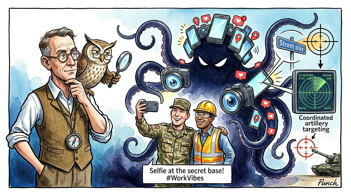
🎩 Dr. Chokepoint Analysis: "In the classic realist framework, states built fortress walls and concealed command bunkers to preserve military secrets. In the 21st century, soldiers inside those very bunkers carry high-definition global tracking beacons in their pockets. You do not need to hack a nation's military satellite network when a recruit willingly broadcasts their location to earn twenty digital likes from strangers. In modern statecraft, digital vanity is the most lethal operational liability."
🦉 Radar's Cynical Take: "The firewall stops the cyber weapon; the selfie kills the general. In the digital panopticon, every smartphone is an uncalibrated targeting radar—and the internet never forgets what you foolishly uploaded for five seconds."
8. Operational Security (OPSEC): Surviving the Digital Panopticon
To protect critical infrastructure and personnel in an era of pervasive open-source surveillance, organizations must enforce five non-negotiable OPSEC doctrines:
- Mandatory Device Isolation in Secure Zones: Enforce strict Faraday storage lockers outside critical operational areas (SCADA control rooms, command centers, and subsea cable facilities).
- Metadata Stripping & Clean Camera Policies: Strip all EXIF GPS tags and camera sensor hashes from public agency communications prior to external release.
- Background Scrubbing: Before publishing any official workplace photo, inspect every square inch of the background for reflective surfaces, window horizons, and equipment serial plates.
- Disabling Fitness Geolocation Sharing: Prohibit military and defense contractor personnel from utilizing public tracking features on civilian fitness applications within 15 kilometers of strategic facilities.
- Continuous Threat Surface OSINT Auditing: Employ red-team OSINT analysts to continuously crawl public web platforms, monitoring employee social footprints to discover and remediate leaked credentials.
Expert Analysis — Bhanu Pratap Meena
"Founder & Hybrid Warfare Specialist: Strategic intelligence assessments in the Social Media Intelligence (SOCMINT) Tracking arena indicate shifting operational dynamics. The technical telemetry and incident vectors analyzed here reveal calculated adjustments by state and non-state actors to exploit structural vulnerabilities before defensive countermeasures can be deployed. Continuous technical and geospatial verification remains paramount."
Related Domain Analysis: Explore our coverage of Intelligence & OSINT Analysis.
Topical Bibliography & References
- Eliot Higgins (2021). "We Are Bellingcat: Global Crime, Online Sleuths, and the Bold Future of News" Bloomsbury Publishing. [Source Link ↗]
- P.W. Singer & Emerson T. Brooking (2018). "LikeWar: The Weaponization of Social Media" Eamon Dolan / Houghton Mifflin Harcourt. [Source Link ↗]
- Michael Bazzell (2023). "Open Source Intelligence Techniques: Resources for Searching and Analyzing Online Information (10th Edition)" IntelTechniques. [Source Link ↗]
- NATO Strategic Communications Centre of Excellence (2020). "Digital Exhaust and Geolocation Risks: Lessons from Fitness Tracking Heatmaps in Operational Theatres" NATO StratCom COE Report. [Source Link ↗]
- David Omand, Jamie Bartlett, & Carl Miller (2012). "The Proliferation of Social Media Intelligence (SOCMINT) in Contemporary Conflict Monitoring" Intelligence and National Security. [Source Link ↗]
Key Takeaways
- In the digital panopticon, every smartphone is an uncalibrated targeting radar for precision artillery and loitering munitions.
- Visual geolocation and chronolocation allow open-source investigators to pinpoint coordinates and timestamps down to the minute.
- Digital vanity compromises secure installations faster than technical vulnerabilities, turning personal selfies into targeting telemetry.
- Strict Faraday isolation, background visual scrubbing, and continuous red-team OSINT audits are non-negotiable OPSEC mandates.
Need a Deeper Operational or Threat Assessment?
International Conflict Studies provides custom open-source intelligence dossiers, geopolitical risk modeling, and critical infrastructure threat diagnostics for enterprise and sovereign decision-makers.
Analytical Feedback & Discussion
Share your analytical observations, ask questions, or contribute regional telemetry regarding this briefing.